Northern Spotted Owl
(Last Revised October 2005)
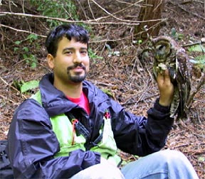
The northern spotted owl (Strix occidentalis caurina) is found throughout the Pacific Northwest, ranging from southwestern British Columbia to Marin County in California. Following a decline in spotted owl habitat, the United States Fish and Wildlife Service (USFWS) listed the spotted owl as threatened in 1990. Although spotted owls are listed as threatened throughout their range, they seem to thrive in the  Spotted owl in a Douglas-fir redwood region of California, specifically on managed timberlands. Current research in northern California suggests that spotted owl densities may be higher on managed timberlands than in quintessential old growth redwood forests. One possible reason for this phenomenon is that in California landscapes where timber harvesting occurs often contain more suitable woodrat habitat, and are therefore more abundant in the primary prey species of spotted owls. However, at present, northern spotted owls are threatened by another owl species, the barred owl (Strix varia), which has made a westward expansion from the east, and is now making its way south along the Pacific Coast. Barred owls are a major cause for concern because they have been displacing spotted owls throughout the Pacific Northwest. Barred owls have been recently detected in several state parks in Mendocino County, but none have been confirmed as of yet on MRC lands. At present, MRC lands, plus outlying areas up to a quarter-mile from its property line, contain 176 active spotted owl territories, at which 124 have produced young since surveys began. Other activity centers likely have owls but are either too young to reproduce or single males that cannot reproduce.
MRC follows all regulatory guidelines related to spotted owls and works in close consultation with USFWS biologists so that timber operations have a low likelihood of incidental take. Current guidelines require spotted owl surveys in and around any timber harvest plan (THP) and monitoring their activity centers to determine precise daytime roost or nest sites. Collecting this information allows for operational flexibility and ensures that areas ecologically important to spotted owls receive a high level of protection. All THP-related survey and monitoring information is available to the public by contacting the Arcata office of the United States Fish and Wildlife Service.
In 2001, MRC biologists started an effort to survey the entire MRC ownership for spotted owls including all THPs. This effort continued through the 2005 season and will continue into the future so that all of MRC's ownership will have been surveyed for owls. MRC's staff is also monitoring all active spotted owl territories for reproductive success. Spotted owl fledgling on a stump. This is part of a research effort that will be combined with banding spotted owls to determine the abundance, turnover rates, and productivity levels of spotted owl territories on MRC lands. Combining productivity data with the landscape planning process will enable MRC to examine the potential relationship between habitat distribution and reproductive success for specific pairs of owls, and thus, provide an empirical benchmark for managing owls on MRC's ownership and achieving goals outlined in a future Habitat Conservation Plan (HCP). Overall, MRC's landscape planning process will allow biologists and managers to plan harvest and maintain owl habitat that is distributed equally across the ownership and across time. Monitoring the number of owls on the ownership, their reproductive success and turnover rate will most importantly allow MRC to use adaptive management to change forest practices if owls begin to decline.
The future for growing more spotted owl habitat on MRC land looks bright. Predictions from MRC's landscape planning process shows that owl habitat will continue to increase across the ownership throughout time. However, a current unknown, remains the range expansion of barred owls into MRC timberlands and how this might affect the northern spotted owl.
Bird Banding
Bird banding is a technique that biologists use to gain insight into life history patterns and population dynamics of birds--information critical for developing sound wildlife management policies. Specifically, information generated from banded birds can be employed to estimate different population parameters such as density, survival, age structure, immigration and emigration rates. Bird banding enables wildlife managers to visually identify individual birds, like the Northern Spotted Owl (Strix occidentalis caurina;NSO), and associate them with a territory, a productivity level (i.e. mean number of fledgling per year), and a detailed reproductive and movement history. This is especially important in managing NSOs that move around the landscape over time.
In 2002, MRC secured all the necessary permits to initiate a banding program on its property to facilitate recovery and adaptive management of the NSO. Since then, MRC biologists have successfully captured, banded, and released 160 NSOs on its forestlands. As the banding program continues, annual banding efforts will be primarily focused on fledglings because most of the adult population will already have been banded. Furthermore, in conjunction with this banding program, MRC biologists are looking to collaborate with other researchers in northern California to monitor the prevalence of the West Nile virus in the NSO population.
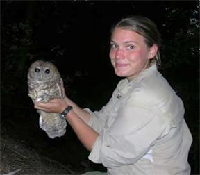
 Obtaining authorization to band a threatened species involves obtaining a bird banding permit from the Bird Banding Laboratory (BBL) in Patuxent, Maryland; a Federal Recovery Permit from the United States Fish and Wildlife Service; and a Scientific Collecting Permit from the California Department of Fish and Game. Banding activities are conducted by experienced biologists using proven capture techniques. The health and well-being of the owl is paramount when a decision to band is made. Bander demonstrating how to hold and band using the one-person technique. Banding is completed, owls ready for release.
Using Radio Telemetry to Track Populations
What is radio telemetry and how is it used with wildlife? Radio telemetry is the science of using radio transmitters and receivers to track wild animals. Representatives of the animal population under study are carefully captured using techniques to minimize impact to them. A battery-operated transmitter is then attached to the individual animal. Once the transmitter is secured, the animal is observed to ensure that the transmitter does not hinder its movement.
Radio signals emitted by the animals' transmitters are detected by a biologist with hand-held receivers. The location of the animal can be calculated by triangulating three compass bearings of radio signals. With this information, wildlife biologists can learn more about the home ranges, habitat use, and movement of the animals within their study.
How does this apply to Northern Spotted Owls? Over the past decade, studies on northern spotted owls have been conducted in areas with extensive young, naturally-regenerated forests or in extensive second-growth forests that surround small patches of late seral and old-growth forests. Many initial studies examined forest attributes characterizing northern spotted owl nest and roost sites. However, much less is known about how northern spotted owls utilize managed landscapes seasonally and while foraging, especially in Mendocino County. Radio telemetry is a useful technique for answering these types of questions.
National Council of the Paper Industry for Air and Stream Improvement (NCASI) initiated a five-year telemetry study in Oregon, Washington, and Northern California to monitor northern spotted owl habitat-use and responses to recent and planned applications of less-intensive forestry practices such as thinning and partial cutting. One goal of the study is to develop and provide scientific information that could promote integrated conservation of the northern spotted owl across a myriad of landscapes. Another goal is to develop a better understanding of what constitutes northern spotted owl foraging habitat.
NCASI is an environmental research resource whose programs address environmental issues associated with forest management practices.
How is Mendocino Redwood Company (MRC) Involved? MRC has provided financial and logistical support and study sites for this project since 2000. NCASI has followed two northern spotted owl territories on MRC lands, and six additional territories on other ownerships in Mendocino County. Five seasons of telemetry work have already been completed; now the last phase - vegetation measurements - are currently being conducted and will conclude this study. The information collected should help clarify northern spotted owl habitat relationships in the Redwood region and promote the conservation of this federally-listed species.