Marbled Murrelet
(Last Revised October 2005)
The Marbled Murrelet (Brachyramphus marmoratus) (MAMU) is a small Pacific seabird found in coastal nearshore waters of western North America ranging from the Aleutian islands in the north to northern Mexico in the south. This species is unique among members of the Alcidae in that it typically nests in trees associated with late-seral and old growth coniferous forests and may travel substantial distances inland to nest sites. Since murrelets do not construct their nests, they must rely upon the presence of old and/or mature trees with large limb diameters, deformities, canopy epiphytes, mistletoe brooms, or debris accumulations for suitable nesting platforms.
Declines in murrelet population numbers throughout their geographic range have been attributed to the species' low fecundity, increased at sea mortalities from oils spills and gill nets, and the increasing removal of suitable nesting habitat. In 1992, these factors prompted the U.S. Fish and Wildlife Service (USFWS) and the State of California to list the Marbled Murrelet as threatened and endangered, respectively.
Mendocino Redwood Company (MRC) works in conjunction with the California Department of Fish and Game (CDFG) and the United States Fish and Wildlife Service (USFWS) to protect murrelets and their habitat on the ownership. In order to determine if murrelets exist within or near timber harvest plans (THPs), surveys are typically conducted for two years in areas containing potentially suitable nesting habitat within 0.25 miles of a THP. MRC works closely with biologists from CDFG and the USFWS to assess potential nesting habitat and to determine an appropriate survey methodology. Despite the opportunity, MRC chooses not to harvest potential murrelet habitat even when no murrelets are detected. In fact, both MRC's old growth and wildlife tree retention policies cover a wide range of rare and unique habitats important to wildlife species, including the marbled murrelet.
In Mendocino and Sonoma counties, murrelet densities are low relative to populations further north in Humboldt and Del Norte counties. Because murrelets are often elusive and secretive birds, they can be very difficult to detect during ground surveys, especially at inland sites having low murrelet densities. In 1999, MRC began using marine radar to examine whether small numbers of silent murrelets were traveling up watersheds to inland nest sites. Although many of these areas contain small isolated patches of potential murrelet habitat, past ground surveys have yielded few or no murrelet detections.
On MRC's forestlands, murrelet surveys have been conducted annually in selected watersheds since 1994 to ascertain murrelet presence in areas of potential habitat and to monitor a known population in lower Alder Creek that was discovered in 1993. Annual surveys in lower Alder Creek since then have routinely detected murrelets, and in a few instances, behaviors indicating murrelets are occupying a stand (e.g., circling and/or subcanopy flights).
Currently MRC is not harvesting timber in lower Alder Creek and is developing a lower Alder Creek Conservation Plan in conjunction with developing a long term sustainable forest management plan that includes the marbled murrelet as a covered species. Currently, MRC has focused survey efforts for murrelets on habitats that have the highest potential for murrelet use. Watershed-level radar and ground surveys have been conducted in lower Alder Creek, Navarro, Albion, Elk, and Greenwood watersheds, with a majority of murrelet-type targets detected in Alder Creek. Since 2002, radar has been used annually at three locations along Alder Creek to monitor the murrelet population here and to determine their eastern extent within the watershed. In 2002 and 2003, for the first time ever, MRC biologists observed murrelets landing and taking off from the same tree in lower Alder Creek. Because MRC is committed to protecting unique habitats utilized by the marbled murrelet, the company will continue to conduct murrelet surveys in and around potential habitat and monitor the population in lower Alder Creek.
Lower Alder Creek
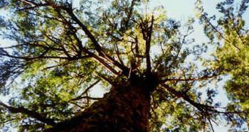
 Lower Alder Creek is a high gradient stream surrounded by steep rocky slopes with many windswept and Lower Alder Creek deformed trees. Portions of lower Alder Creek contain patches of old growth redwood and Douglas fir that serve as habitat for marbled murrelets. Many of the mature second-growth conifers, particularly Douglas fir, are deformed from disease and storm damage and may also contain nesting platforms suitable for marbled murrelets. Much of the suitable habitat in Alder Creek is atypical compared to what is commonly described as murrelet nesting habitat elsewhere in the murrelet's range (e.g. moss covered, decadent old growth trees). The unique growing conditions, rugged topography, relatively short distance to the coast, and minimal logging activity in many stands have allowed a murrelet population to persist in Alder Creek over the years. Additionally, because few murrelets have been detected outside of Alder Creek in Mendocino county, it appears that lower Alder Creek represents one of the last remaining historical refuges for the marbled murrelet within the county.
Marbled Murrelet Habitat Discovered
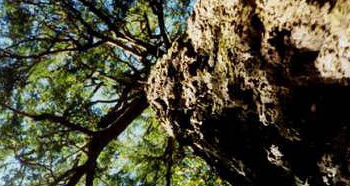
 Eggshell fragments were found below tree in lower Alder Creek. Another view showing deformed limbs with platforms. In September of 1993, consultants cruising timber stands in lower Alder Creek encountered eggshell fragments that were later confirmed as being occupied by Marbled Murrelets. Since this discovery, lower Alder Creek has intrigued many biologists because the habitat used by murrelets here is so radically different from other areas where murrelets nest. This area really bucks the trend when it comes to the habitat characteristics commonly cited as important to murrelet occupancy and reproduction.
The following information was obtained from a memorandum distributed to the California Department of Fish and Game, the United States Fish and Wildlife Service, and several murrelet biologists in the region.
Nest Site The location where eggshell fragments were found is approximately three acres in size and is largely dominated by Douglas-fir (Pseudotsuga menziesii). Other species within the stand include California bay (Umbellularia californica), Pacific madrone (Arbutus menziesii), canyon live oak (Quercus chrysolepis), California nutmeg (Torreya californica). Vegetative characteristics were measured within a 30-meter radius circular plot centered at the possible nest tree. Douglas fir trees within the plot had a mean diameter at breast height (DBH) of 28.6 inches and a mean height of 92.3 feet. Three trees within the plot were aged to ca. 85 years using an increment borer at breast height. The stand has a single canopy layer and a crown closure around the nest tree of approximately 30 percent.
Nest Tree The possible nest tree is an 85 year-old Douglas fir having a DBH of 51.2 inches and a height of 121 feet. This tree is located on the lower third of the slope (elevation 640 feet), which has an aspect of 164 degrees and a declination of 98 percent. The nearest perennial source of water, Alder Creek, is located 600 feet downslope. The closest opening to this site in an abandoned logging road located 180 feet upslope.
Nest Stand The stand surrounding the three acre 'nest' site is comprised of coast redwood (Sequoia sempervirens) and Douglas fir trees that are 10-20 inches in size (DBH) with a canopy closure of 40-70 percent. This stand, which has a history of timber harvest and no evidence of fire, is approximately 60 acres in size.
Radar Surveys For Marbled Murrelets Radar is electromagnetic radiation that is sent out to scan terrain for a particular object. Once the electromagnetic energy hits the object, a small amount of the energy is reflected back to the receiver (antenna). This reflected energy creates a picture of the object being scanned. The time it takes for the reflected energy to hit the receiver is used to calculate the distance to the object. The object's speed can also be calculated using radar.
Although murrelet ground surveys are still necessary, one of the limitations of ground surveys is the low light conditions in which a ground observer must work making positive murrelet identification difficult. Even audio murrelet detections cannot provide accurate data on the number of birds and their flight direction. It's also difficult for a ground observer to determine whether murrelets that are flying over an area actually occupy the site or whether they are simply on their way to another site. Radar, however, provides some helpful solutions to ground survey limitations. In addition to determining whether murrelets are present in an area, radar scans can approximate the number and flight direction of murrelets detected. Thus, radar surveys can assist wildlife biologists to locate forested stands that are being used by marbled murrelets.
Recently, MRC contracted with Hamer Environmental to conduct radar surveys for marbled murrelets in the Albion River, Navarro River, Greenwood Creek, and Alder Creek watersheds. The radar survey results will help MRC biologists to prioritze murrelet ground survey work.